 August 2, 2008 Saturday
Up early, showered and breakfast before heading to the Baked Café for coffee and WiFi. The sun was out and intense. It was 39 F when we woke up and by 9am it must have been 80 F. The sun is incredibly strong here. I took care of internet business the first 3 hours then Bruce and I toured part of the town on foot. Whitehorse has all the amenities of any medium size town and it’s downtown is vibrant. We went to the bookstore, bank and ate at a chuck wagon type eatery. We walked part of the Trans Canadian Trail that hugs the Yukon to the Klondike Steamer that sits aground along the water’s edge.

We thought about getting on the Alcan Hwy and start heading south but after about a 2 minute conversation we decided to head to Dawson City 327 miles north. There is a loop that can be done on the way back and we’re not quite ready to leave the Yukon. It is so wide-open and peaceful here. The water is clear, the air clean, no traffic, bright sun….let’s stay a bit longer.

So, with little research, we’re off to Dawson City six hours north, just 200 miles south of the Artic Circle as the crow flies. The view along the way is similar to Montana (big sky), just much bigger, fewer roads (and people) and more space. The history with the Klondike Gold Rush of 1896-1898 was of historical interest to me at one time. I read many books years ago about this major event and visiting it in the flesh will be a treat. Bruce is also interested in its history.
 Geologically the Yukon is diverse and has the Tintina Trench, the largest fault in N. America that cuts through the Yukon NW to SE right along the Klondike Hwy (the road we’re traveling to get to Dawson City). This geological area is responsible for the gold exposure and a climate that support fowl migratory routes and other wildlife.


The road is in good shape however, there are areas covered with gravel and there is perpetual pothole work being done on the paved portion. There is a book that is a must to pick up prior to traveling this road; Yukon’s Wildlife Viewing Guide. This gives you mile markers of the main roads and pull-offs and locations of special interest areas (geological, wildlife, flora and fauna and historical). It is specific to all the main highways in the Yukon.
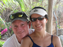
Bruce's photo of the year!

Today’s highlight was a Red Fox trotting along the road with a freshly dead squirrel.

The entire province of Yukon is only populated with 37500 residents and most of them live in Whitehorse. This country is for the rugged and/or peaceful naturalist, the avid hunter or the psycho and/or antisocialist. If you live in the Yukon you don’t want to be bothered. Even their sparse roads have names. We’ll be taking the “Top of the World Highway” to Tok, Alaska (provided it’s not 180 miles of gravel) from Dawson City, and then at that point we’ll get on the Alcan Highway and drive through the southwest portion of the Yukon…that is if we don’t change our minds.
 We had a spaghetti dinner at the Klondike River Campground with many uninvited guests; mosquitos! I think Citronella candles and the campfire attracts them. Lavendar oil and garlic is no match for these pesky rascals. Luckily, my coworkers gave me a bottle of a highly concentrated DEET and a mesh net to put over my head. Unfortunately, I misplaced the bottle yesterday but was saved with an old can of OFF and the net. If I were Native American my name would have been “Swats with One Hand Eats with the Other”, or “Net Head”. Bruce’s name would be “He Who Starts Massive Camp Fire Using Flammable Liquid”. No disrespect intended.
Another beautiful day in the neighborhood as the evening closes with a warm hardy (albeit augmented) campfire. The sun should be going down around midnight.

No comments:
Post a Comment